Edited by: JV Staff
Just in time for the arrival of fall’s splendor, the Pocono Mountains has been chosen by USA TODAY 10Best readers as the 4th Best Destination for Fall Foliage for 2019. This is yet another year the region has been recognized as one of the best spots to see the leaves change.

“The Pocono Mountains are ablaze with hues of red, orange and yellow come autumn, thanks to the area’s 127 species of indigenous trees, plants and shrubs,” states USA TODAY 10Best. “Leaf peepers can hop in the car for a scenic cruise along Route 507 near Lake Wallenpaupack or climb aboard a fall foliage train.”
Nominees were chosen by a panel of experts including editors from USA TODAY and readers were able to cast their votes once daily on the 10Best.com website.
The Pocono Mountains is beginning to see those vibrant oranges, yellows and reds atop the trees throughout our four-county region. There are numerous ways to take in autumn’s natural beauty including driving through the heart of the Delaware Water Gap National Recreation Area on Route 209 or Route 6 takes you through the historic towns of Milford, Hawley and Honesdale where you can dine, shop and bask in the surrounding fall foliage.
Currently, the Pocono Mountains Visitors Bureau provides a fall foliage forecast updated every Thursday through the end of October that helps visitors and residents know where, when and how to experience the season and its brilliant views.
The fall season has only just begun. There’s so much to do in the Pocono Mountains whether it’s by train, on the golf course, on the river or in the pumpkin patch, and the Poconos is very proud to have been recognized for being a top destination for fall foliage.
Answers to common Poconos fall foliage questions
- What scenic drives can we take to view the foliage?
- When do the leaves start changing color?
- When is the best time to visit for the foliage?
- Where is the best place to visit to view the foliage?
- Which area is currently at peak?
- How long does the foliage season last?
- Which region of the Pocono Mountains peaks first?
- What festivals/events are taking place during the fall?
- Are there any scenic chairlift rides to view the foliage?
- Where can we go hiking and view the foliage?
- Where is the best place to take pictures?
- Which species of trees turn color in the Pocono Mountains?
- What makes the leaves turn color?
- Where can I go to see a variety of colors in one location?
- Scenic Drives
- What scenic drives can we take to view the foliage?
A: The Pocono Mountains is etched with gently winding, wooded roads perfect for leaf peeping. Some scenic routes have even received national attention for their fall foliage views. In 2013, Travel called Route 507 around Lake Wallenpaupack one of its “Best Fall Foliage Road Trips.” PA Route 6 was ranked among the “Top Scenic Routes in America” by Car and Driver Magazine, and was recognized by the Harley-Davidson Company as “Pennsylvania’s Best Tour Road.” For more information on these and other scenic drives in the Pocono Mountains, look to our list of roads below, and plan your autumn outing today!
- When do the leaves start changing color?

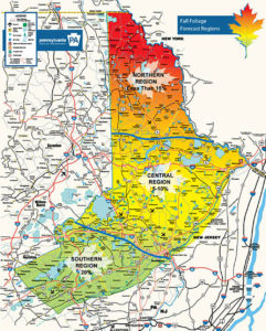
A: The vast Pocono Mountains region encompasses three distinct fall foliage color zones. Start and peak times vary between the three areas. Depending on conditions, leaves begin to turn in mid-September and reach their peak in early to mid-October. Our weekly Fall Foliage Forecast provides the most accurate information on fall color in the Pocono Mountains.
- When is the best time to visit for the foliage?
A: Peak times vary between the region’s three color zones. Determine when your destination will be in full color by consulting our weekly Fall Foliage Forecast.
- Where is the best place to visit to view the foliage?
A: While tint and timing differ among the region’s three color zones, all areas of the Pocono Mountains will be edged with fall foliage at certain times throughout the season. Select your destination, and then check projected peak time using our Fall Foliage Forecast!
- Which area is currently at peak?
A: Updated weekly, our Fall Foliage Forecast notes the percentage of color, percentage of leaves on trees, and projected date of peak for the region’s three distinct color zones.
- How long does the foliage season last?
A: Depending on conditions, leaves begin to turn in mid-September and reach their peak in early to mid-October. Lingering leaves and autumn activities can be enjoyed through the end of the October. Look to our list of fall festivals and fall activities for a list of seasonal celebrations and be sure to consult our Fall Foliage Forecast for autumn updates.
- Which region of the Pocono Mountains peaks first?
A: Projected peak times for the Northern, Central, and Southern regions of the Pocono Mountains can be found in our Fall Foliage Forecast.
- What festivals/events are taking place during the fall?
A: Find the full lineup of autumn events on our fall festivals and fall activities pages!
- Are there any scenic chairlift rides to view the foliage?
A: See the trees on a scenic chairlift ride at Shawnee Mountain! Rides are offered during select fall festivals on the property.
- Where can we go hiking and view the foliage?
A: More than 260 miles of hiking trails wind through the four-county region of the Pocono Mountains. With so many routes to choose from, you’re sure to find the perfect leaf-peeping pathway! Check out our list of hiking trails, or head to one of our National, State and Local Parks.
- Where is the best place to take pictures?
A: Many of the region’s hiking trails and parks feature scenic overlooks and picture-perfect vistas. Find foliage and falling water at sites like Bushkill Falls, or stroll the streets of one of our charming downtowns! All areas of the Pocono Mountains will see autumn color at some time this season. Check our Fall Foliage Forecast for peak dates and information!
- Which species of trees turn color in the Pocono Mountains?
A: The Pocono Mountains region is home to more than 127 varieties of trees, shrubs and plants. Deciduous trees are those that lose their leaves for part of the year. In the Pocono Mountains, trees including maples, oaks, birches and aspens will add to the autumn colors.
- What makes the leaves turn color?

A: According to the US Forest Service, three factors influence autumn color: leaf pigments, length of night, and weather. In autumn, the chlorophyll in leaves begins to break down. Green color disappears and yellow to orange colors become visible. Additional chemical changes may occur, leading to the development of certain pigments and red or purplish colors.
- Where can I go to see a variety of colors in one location?
A: Take a stroll or drive along the scenic Delaware River! CNN has named the Delaware Water Gap one of the best places to view fall foliage. The picturesque Pocono Mountains destination is home to a wide variety of tree species.
- SCENIC DRIVES
View our geographic map of the Pocono Mountains to see our three fall foliage color zones and find the route that’s right for you!
ROUTE 611 from Portland to Delaware Water Gap
ROUTE 390 from Mountainhome to Canadensis to Skytop to Promised Land to Tafton
ROUTE 209 from Bushkill to Dingmans Ferry to Milford to Port Jervis
ROUTE 209 from Kresgeville to the Beltzville Dam and Reservoir
ROUTE 84 from Milford to Greentown to Mt. Cobb to 380
ROUTE 715 to “Sullivan’s Trail” from Tannersville to Pocono Pines
ROUTE 191 from Bangor to Stroudsburg to Analomink to Paradise Valley to Cresco to Mountainhome to Newfoundland to Hamlin to Honesdale to Rileyville to Lookout.
ROUTE 903 from Fern Ridge to Jim Thorpe
ROUTE 534 East through Hickory Run State Park to Beltzville
ROUTE 447 from Analomink to Canadensis to Newfoundland
ROUTE 115 from Brodheadsville to Blakeslee to Bear Creek
ROUTE 715 from Brodheadsville to McMichaels to Reeders to Tannersville to Henryville
ROUTE 590 from Greeley to Lackawaxen to Hawley to Lakeville to Hamlin
ROUTE 402 from Marshalls Creek to Porters Lake to Peck’s Pond to Lake Wallenpaupack to Route 6 West through Hawley and Honesdale to Route 191 North to Route 507 North around Lake Wallenpaupack
ROUTE 6 East to Milford to Route 209 South through Delaware Water Gap National Recreation Area
ROUTE 380 TO 507 from Gouldsboro to Newfoundland to Greentown to Paupack to Route 6 to Honesdale
ROUTE 371 from Damascus to Rileyville to 247 to Rock Lane to Lake Como
Route 652 from Narrowsburg, NY to Honesdale to 670 to Pleasant Mount
Pocono Mountains visitor information is available online at PoconoMountains.com or by phone at (570) 421-5791. Follow @PoconoTourismPR on Twitter to stay current with up-to-date information. Established in 1934, the Pocono Mountains Visitors Bureau is a private, non-profit membership organization. The PMVB is the official destination marketing organization for the four counties of Wayne, Pike, Monroe, and Carbon in Northeastern Pennsylvania.


